May 2026 - Added DX Spots
As a result of user demand, DX Spots have been added.
Introduction
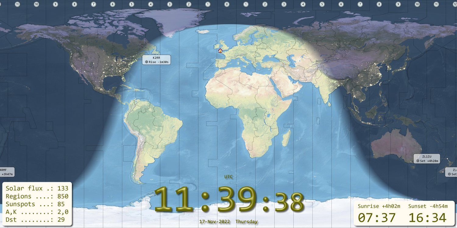
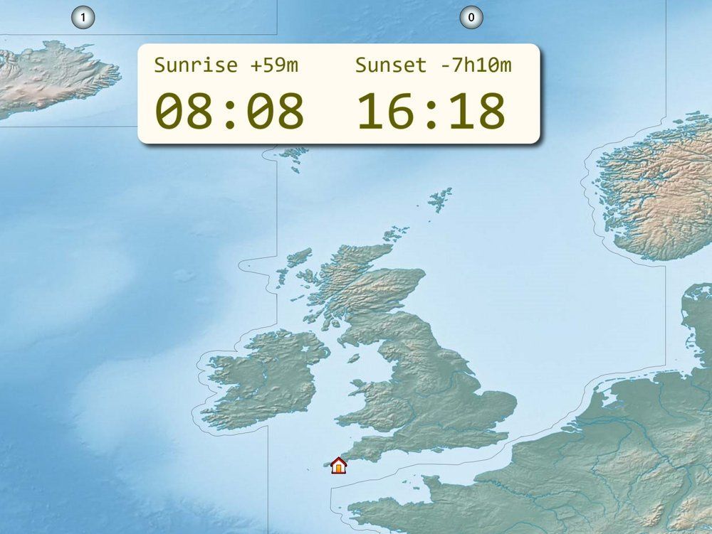
Now that I'm working DX on 80m I need a simple display which shows me at the very least:
- Current Time
- Sunrise / Sunset
- Greyline map
- DX stations
There are commercial geo clock solutions such as Geochron, but as a programmer with spare 4k monitors and computers I decided to write my own, that way I have exactly what I want.
💾 Download
Cut out the jibber-jabber, get the latest kit!
Software
This is a rewrite of a previous project from many years ago. It requires minimal CPU power, will run on any Windows 7 / 8 / 10 / 11 system using x86 architecture. Written to learn new areas of Direct2D graphics and new features of Visual Studio 2022. As time permits the program will be updated; there are interesting ideas in the pipeline.
Rotators
Full support for the ERC Mini, ERC V4 and all Yaesu GS232A/GS232B rotators. DDE interface for other software such as PST Rotator.
Map Projections
Equirectangular Projection
The equirectangular projection is a mapping technique where meridians are represented as vertical straight lines with constant spacing, and circles of latitude are depicted as horizontal straight lines with constant spacing. This projection is commonly used in cartography and for creating panoramic images.
Citations:
[1] https://en.wikipedia.org/wiki/Equirectangular_projection
[2] https://wiki.panotools.org/Equirectangular_Projection
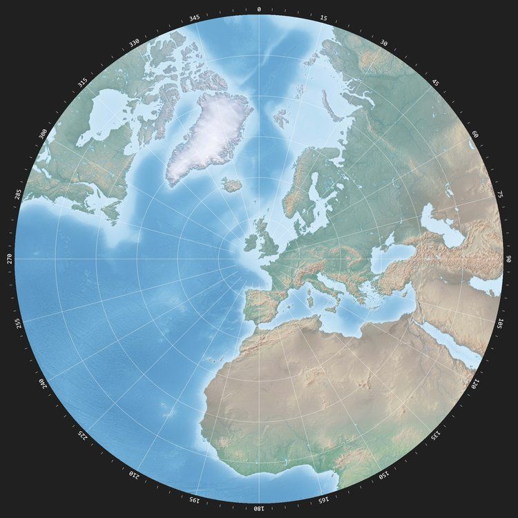
Azimuthal Equidistant
An azimuthal equidistant projection is a type of map projection where all points on the map are at proportionally correct distances from the center point. This projection is commonly used for specialized purposes, particularly for mapping polar regions. The meridians in this projection appear as straight lines originating from the pole, making it useful for specific mapping needs[1][2][5].
Citations:
[1] https://en.wikipedia.org/wiki/Azimuthal_equidistant_projection
[2] https://pro.arcgis.com/en/pro-app/3.1/help/mapping/properties/azimuthal-equidistant.htm
[3] https://flatearth.ws/azimuthal-equidistant
[4] https://youtube.com/watch?v=LNZfK0ESIMo
[5] https://gisweb.massey.ac.nz/topic/webreferencesites/Digital%20Maps/dean/src/warnercnr.colostate.edu/azimuthal.html
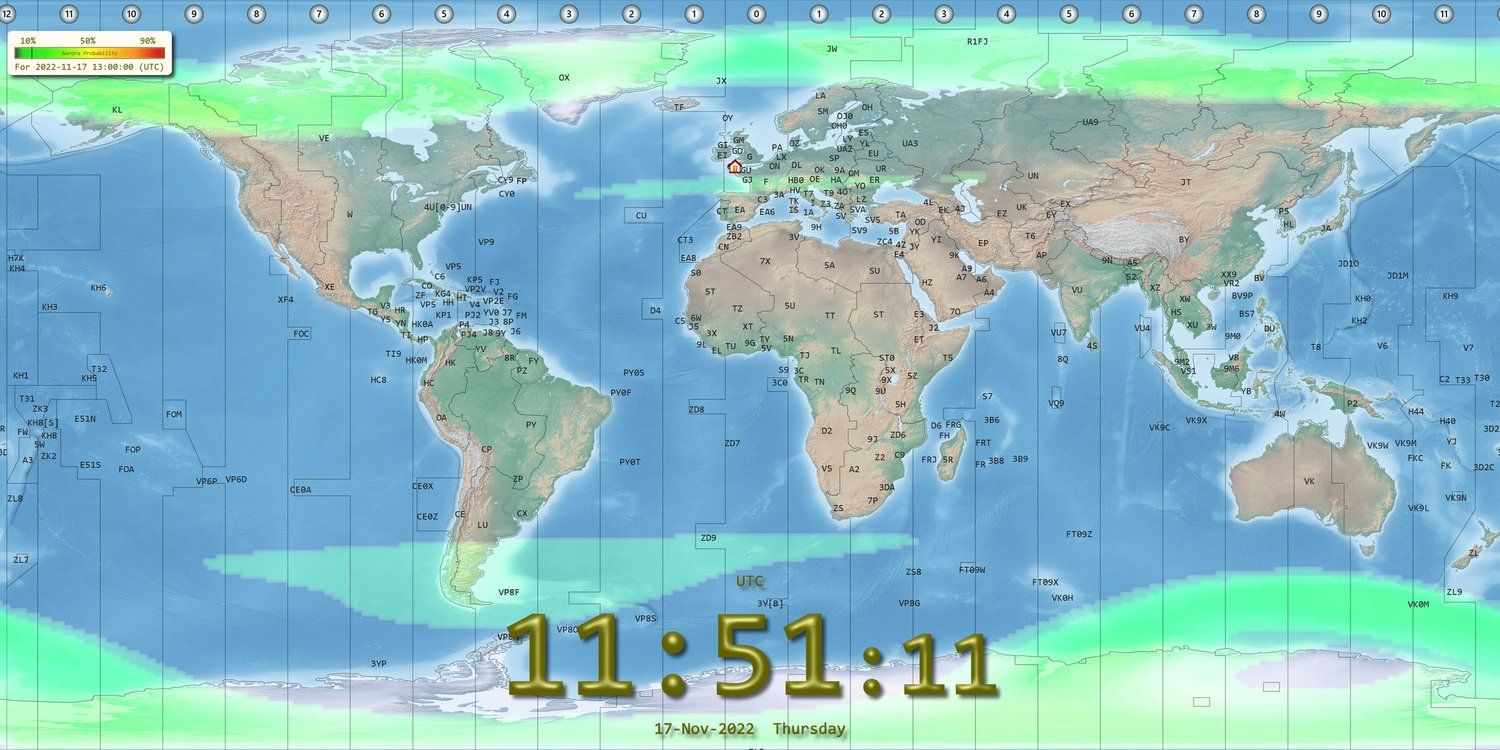
Aurora
Aurora light, also known as the northern lights (aurora borealis) or southern lights (aurora australis), is a natural light phenomenon. It is a stunning display of colourful lights in the sky caused by the interaction between solar wind and the Earth's magnetic field[2]. Aurora Lighting is a global manufacturer of energy-saving lighting solutions, offering products across various lighting elements like power and control[1]. The Aurora Lighting Group, established in 1999, specializes in providing quality and affordable LED products and smart lighting for residential use[5]. If you are looking to purchase Aurora lighting products, you can find a variety of options including LED star projectors and downlights from retailers like Amazon and Downlights Direct[3][4].
Citations:
[1] https://auroralighting.com
[2] https://en.wikipedia.org/wiki/Aurora
[3] https://www.downlightsdirect.co.uk/aurora-lighting.html
[4] https://www.amazon.co.uk/Aurora-Lighting/s?k=Aurora+Lighting
[5] https://www.ledbulbs.co.uk/collections/aurora
Greyline
Greyline radio propagation refers to a phenomenon where radio signals travel along the "grey line," which is the band around the Earth separating daylight from darkness as the Earth rotates. This type of propagation is very efficient, especially at dawn and dusk, due to factors like the rapid disappearance of the D layer that absorbs HF signals at sunset[1][2]. It is a significant aspect of HF radio propagation and is known for enhancing signal reception quality[4]. The grey line propagation offers unique opportunities for radio communication enthusiasts to make long-distance contacts and experience enhanced signal strength[5].
Citations:
[1] https://dx.qsl.net/propagation/greyline.html
[2] https://www.electronics-notes.com/articles/antennas-propagation/ionospheric/greyline-propagation.php
[3] https://youtube.com/watch?v=mXdkBnI3dMU
[4] https://rsgb.org/main/technical/propagation/greyline-around-the-world-propagation/
[5] https://www.m0mcx.co.uk/working-the-gray-line/
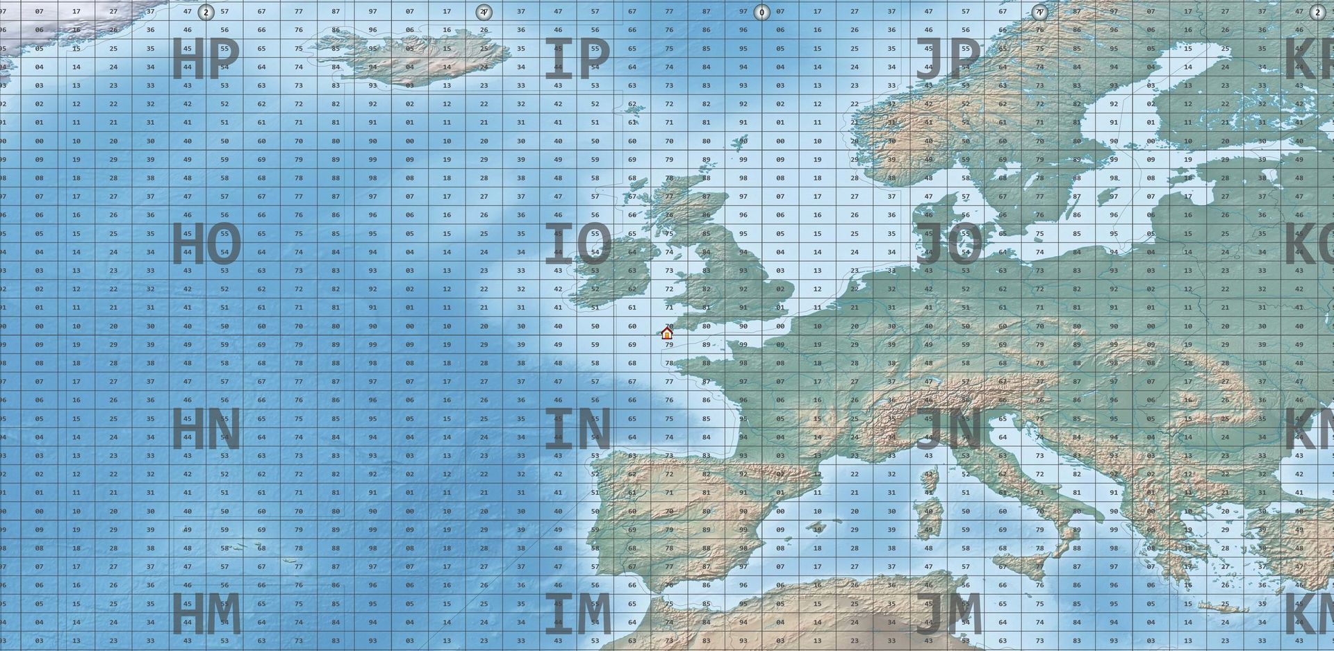
Maidenhead Locators
Maidenhead locators, also known as Maidenhead grid squares, are a system used by amateur radio operators to identify locations on the Earth's surface. These locators are alphanumeric codes that divide the world into a grid. You can find your Maidenhead Locator or Gridsquare by using your postal address on websites like WhatsMyLocator[1], LevineCentral[2], KarhuKoti[3], and others. By entering your zip code, city, latitude, or longitude, you can pinpoint your location on a map and determine your Maidenhead grid square. This system is particularly useful for ham radio enthusiasts to communicate their precise location effectively.
Citations:
[1] https://www.whatsmylocator.co.uk
[2] https://www.levinecentral.com/ham/grid_square.php
[3] https://www.karhukoti.com/maidenhead-grid-square-locator
[4] https://dxcluster.ha8tks.hu/hamgeocoding/
[5] https://www.egloff.eu/qralocator/Maidenhead locators, also known as Maidenhead grid squares, are a system used by amateur radio operators to identify locations on the Earth's surface. These locators are alphanumeric codes that divide the world into a grid. You can find your Maidenhead Locator or Gridsquare by using your postal address on websites like WhatsMyLocator[1], LevineCentral[2], KarhuKoti[3], and others. By entering your zip code, city, latitude, or longitude, you can pinpoint your location on a map and determine your Maidenhead grid square. This system is particularly useful for ham radio enthusiasts to communicate their precise location effectively.
Citations:
[1] https://www.whatsmylocator.co.uk
[2] https://www.levinecentral.com/ham/grid_square.php
[3] https://www.karhukoti.com/maidenhead-grid-square-locator
[4] https://dxcluster.ha8tks.hu/hamgeocoding/
[5] https://www.egloff.eu/qralocator/
💾 Download Now
Click on the image to
go to the downloads section.
Support
If you have questions, there are two support groups:
- The SDR-Radio.com mailing list,
- The SDR-Radio.com online forums.

Greyline
Aurora
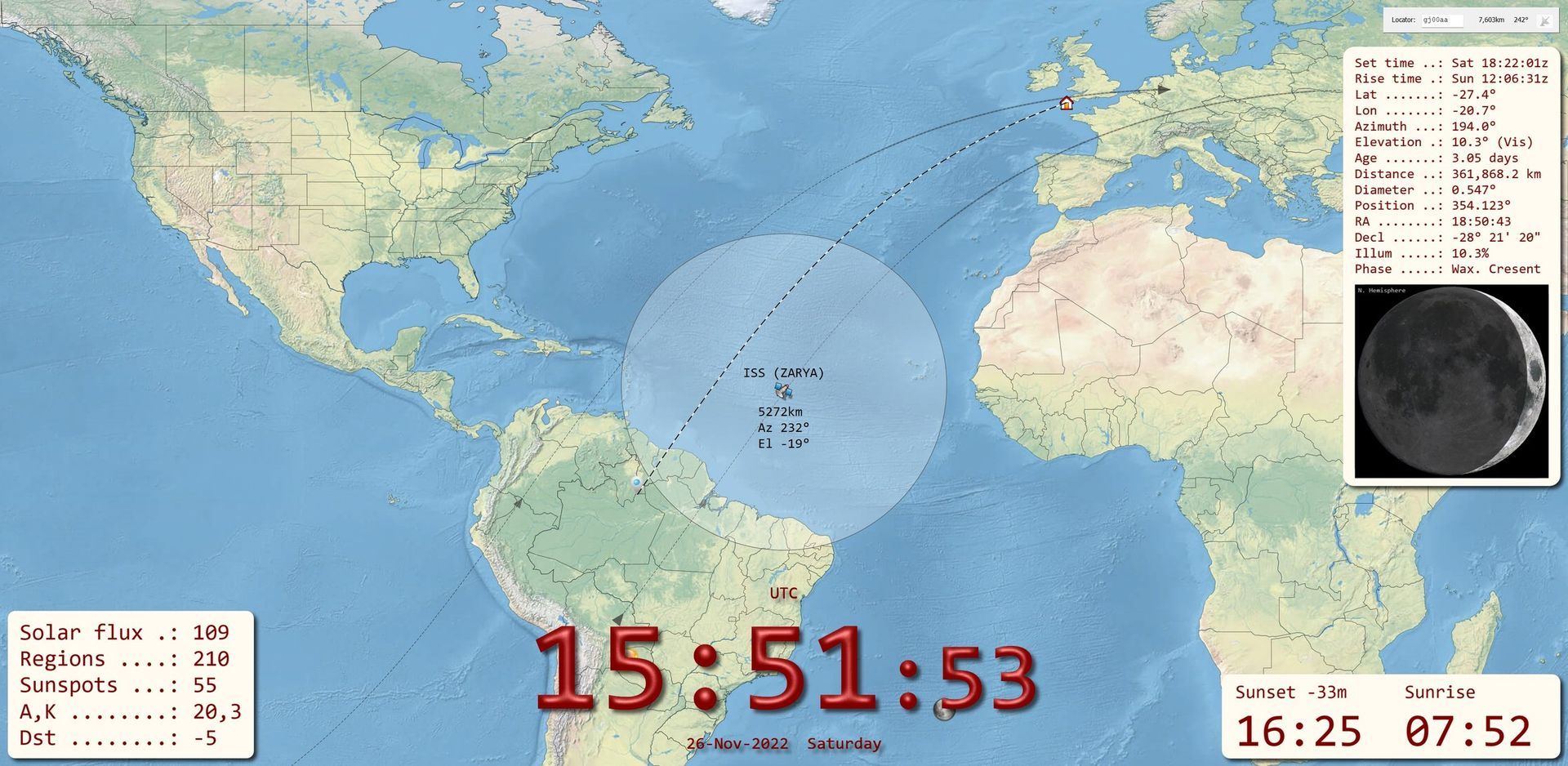
Satellites
Maidenhead Squares
CQ & ITU Zones
Sunrise/Sunset
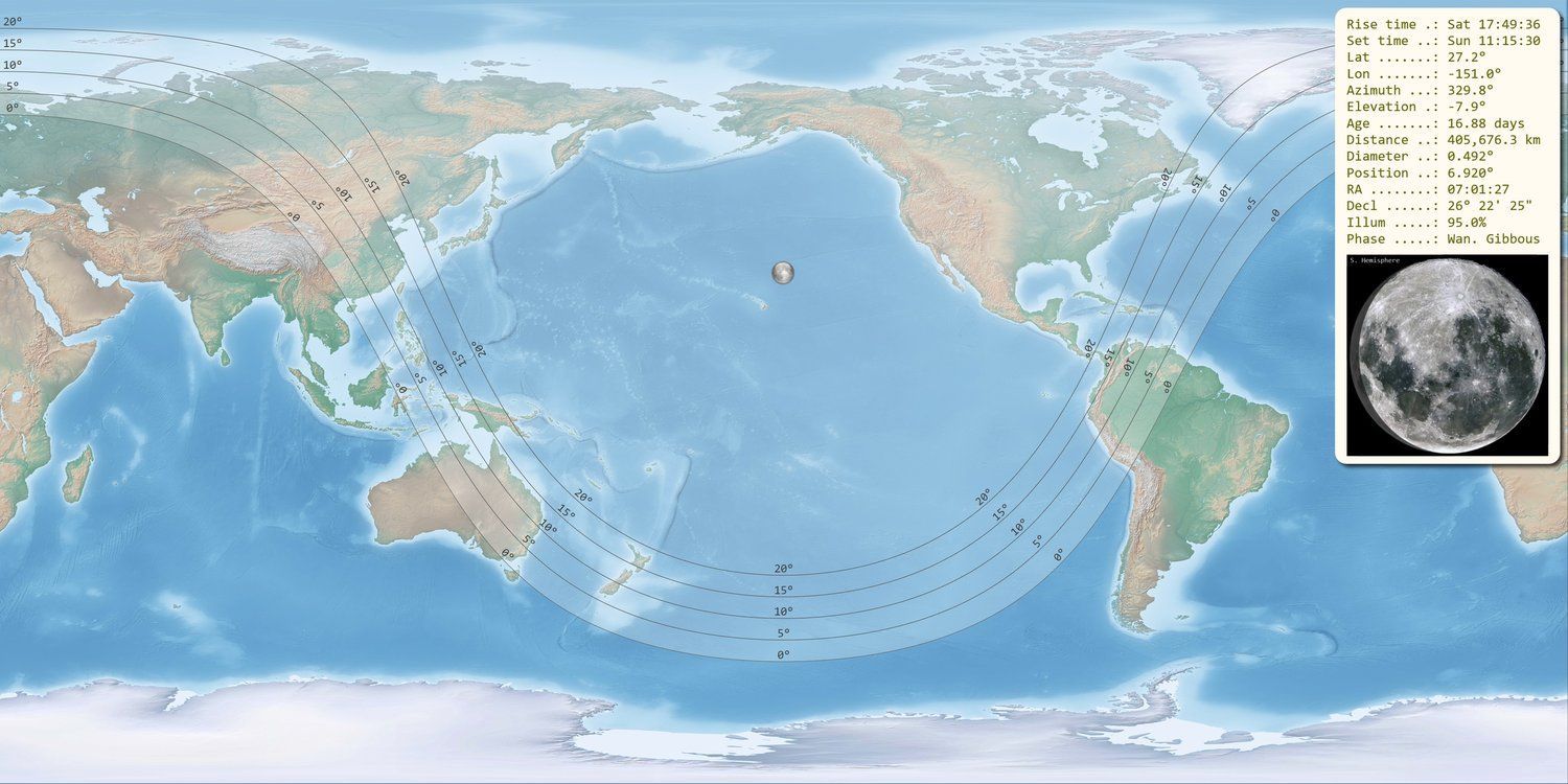
Moon Footprint & Status
Great Circle
💾 Downloads
These kits are signed, there is NO need to uninstall old kits. If the program will not start, make sure the
C++ redistributable is correctly installed.